It was Aisa’s idea that we check out the San Juanico bridge after we have toured Biri Island. So the plan was instead of flying back to Manila through Catarman, we would take a very long road trip from Catarman to Calbayog and then to Catbalogan (basically the length of Samar), all the way to Tacloban, where we’ll fly out. At some point, we’d get off the vehicle before entering the San Juanico bridge and walk all the way to the Leyte side.
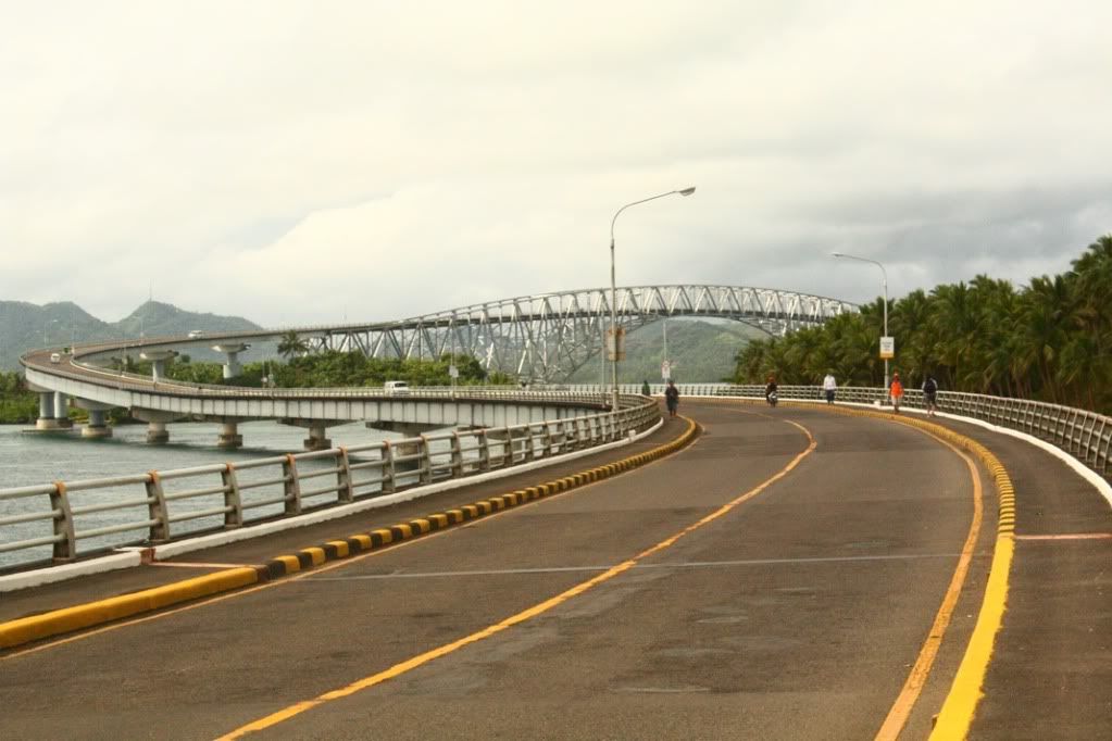
The San Juanico Bridge is a 2-kilometer steel and concrete bridge connecting the Waray-speaking islands of Samar and Leyte. It was also known as the Marcos bridge after the former president, under whose administration the bridge was constructed. It is considered to be the most beautiful bridge in the country and we intended to find out whether it was true.
But before that, we had to spend the night in Catarman. It was drizzling when we arrived at the town after the long jeepney ride from Lavezares. We hired a pedicab to take us to the lodging house beside the Church. In that early evening, we first had dinner at the local Mang Inasal and right after, walked around the town to look for the terminal of the Tacoban-bound vans to make transport arrangements. And soon after, we went back to the lodging house to get some much-needed sleep.
The time of departure the next day was 5am, and we were required to be at the terminal at 4:45am. We almost thought we wouldn’t make it due to a few nervous minutes of trying to wake up the gatekeeper of the lodging house, who locked the front door, thus preventing us from getting out. Fortunately, we managed to wake her up just in the nick of time. Upon arriving at the teminal, it didn’t take long before we boarded and left Catarman for Calbayog.

A helpful reminder in the Calbayog-Catbalogan van.
I must say that the road from Catarman to the San Juanico Bridge is well paved. It was so smooth and free of obstruction that the 4 hours guaranteed travel time – which we had some difficulty believing at first – was easily fulfilled. I would have wanted to explore Calbayog and Catbalogan, both of which we just breezed through en route. Maybe next time. By 9am, we reached the entrance to the bridge on the Samar side, and we then asked the driver to stop so we could alight and walk all the way to the Leyte side.
From that point onwards it was just snapping photo after photo whether using a camera or with our BlackBerrys. It’s a good thing that the volume of vehicles wasn’t high because we spent an awful lot of time standing in the middle of the road.
And so, photos:

Exhibit A: How not to look like a tourist. – CORRECT

Exhibit B: How not to look like a tourist. – WRONG

the bridge proper from a short distance away

at the truss bridge proper

view of Leyte from the bridge

small boat

big boat

view of the Samar end of the bridge, originating in the town of Sta. Rita
Nothing further to say except that I did notice something that never gets mentioned in the tourist guidebooks, i.e., one could observe a lot of small whirlpools forming in the water under the bridge. Unfortunately, at that time they seemed so insignificant that I didn’t take a picture of them.
After reaching the Leyte side, we boarded a jeepney that took us to Tacloban City proper and from then on just basically waited for the time to pass until we needed to get to the airport for the flight back to Manila. We tried to tour the city itself but the weather was erratic – one moment it was scorching hot and the next, it was raining hard – so we stayed mostly in fastfood restaurants. Add that to the fact that we were physically tired from the long hike on the bridge, the choice to stay put wasn’t too hard to make.
After waiting a few more hours in the crowded Tacloban airport, we finally boarded. Homeward bound at last.

sana yung pic ng vessel, yung nakafocus si kuyang kumakaway.hehe. nice post chits 🙂 thanks sa pagmention 🙂
Hehe, sige, idagdag ko mamaya. Ey, I’ll follow you sa twitter ha. ;D
What a cool idea. Walk the length of the San Juanico bridge. I would like to do that now. I’m sure my asawa will not, but maybe I can get someone to do it with me. I live in Calbayog, but we go that way 2 or 3 times per year. Thanks for the idea.
Thanks for visiting, UJ. Last I heard, these days, they are supposedly more strict in allowing tourists to take photos while at the bridge. A friend of mine got accosted for that reason, but I suspect it was largely because they stopped their vehicle on the bridge itself, thereby obstructing traffic. I suppose it would still be okay to walk the entire length to take photos as long as one does not cause any obstructions. There are sidewalks on both lanes anyway.
Yes I have been over the bridge many times and have noticed the sidewalks. I have even seen people walking across it. It wasn’t until I read your post though that I actually thought of doing it myself. I think you are right about your friend and him blocking the traffic.
I visited your website because I was looking for an interesting site written in English by a Filipino that I could follow and get ideas for my own website (just click on the UJ above). I’ve lived here in the Philippines for a little over 2 1/2 years, but I do not speak any of the local dialects or Tagalog so it’s hard for me to understand everything that is going on. I try, but there is so much going on, it’s too easy to miss things.
I am now signed up for any further posts via email to this site and I will be reading on a regular basis from here on out.
How is the weight loss going? I need to lose weight too. A lot of weight (about 100 lbs).